
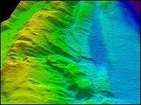
UK scientists have released images of the ocean floor near the epicentre of December’s giant Asian earthquake. They were obtained by the Royal Navy’s hydrographic survey ship HMS Scott. The three-dimensional pictures detail the deformed seabed 150km (94 miles) off the Sumatran coast, and reveal huge underwater landslides.
The images show clearly the boundary between the Indian and Burma tectonic plates – a region known as the Sunda Arc. The flat Indian plate shows up in purple, which turns to blue as this portion of the Earth’s oceanic crust disappears underneath the Burma micro-plate (part of the Eurasian plate). The forces created by this process have rumpled and buckled the surface rocks, whose folds show up in green and yellow.